All through the trip, Hanne was looking forward to a "real vacation" sitting by a pool soaking up the rays (so she could show off her "sun vacation" to her friends, I think) and reading. We had brought along a lot of books to read poolside! So that is why Palm Springs was on the itinerary. Sun, and a trip to all the malls at Cabazon on the way home.
Unfortunately, the winds were blowing fiercely when we arrived at the hotel, which is somewhat obvious in this picture - although the winds had died a little by the next day. As we approached the "desert cities" everything looked rather misty - but that was because of the sand storm. Nevertheless, we got into our bathing suits and went down to the beautiful and long hotel pool. But the wind was blowing so hard that sitting with a book was really out of the question. So we swam a number of laps, stopping now and then to remove chairs that had blown into the pool (raised backs proved to be great sails!) and also stopped the large bin of used towels from rolling into the pool. Afterwards we warmed up in the whirlpool, and left to check out downtown Palm Springs. We found a great Italian restaurant, the Tuscan Grill set back a little on Palm Canyon Drive, walked around a bit and then went back home.
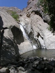
The next day we took a 2-hour hiking tour of Taquitz Canyon so we did get a bit of nature and exercise in. I have annotated the pictures on Flickr to some extent, so you can read about it there. I have wanted to see this canyon ever since our first visit to Palm Springs, when it was closed. It had been pretty much trashed by hippy types (like my cousin, I understand) who grew pot and skinny dipped in the lovely pools. The pool in the picture was also the site of one scene of the movie Lost Horizons.
For the second evening, I suggested a movie, and eating at The Nest Restaurant, which John and I had discovered in Indian Wells a couple of years ago. It has been popular with Frank Sinatra's crowd back in the early days, and lies in connection with the Sands Hotel, out in an area that must have been way out of town back then. I had forgotten that it, too, (of course) was Italian, making it at least the 5th Italian restaurant of the trip. Then we went to a second run movie theater in Cathedral City, where one adult and one senior cost a total of about $3.75, followed by a trip back downtown where we got enormous concoctions at the the Coldstone Creamery Ice cream store!
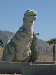
On the way to the malls at Cabazon (and home) the next day, we pulled off at the Cabazon exit of Interstate 10 - officially in the town of Banning, which I have always wanted to do. (The malls are at Fields Road.) The picture shows what we saw there. The dinosaurs have been bought up by some fundamentalist Christian (see the Questions and Answers page,) to make an amusement park to "prove" that there were people around along with the dinosaurs (just like in the comic books of my childhood.)
And that was the end of our wonderful road trip, as Hanne had to leave the next day. The next week or so I spent going through all the stuff that had collected in my absence (and writing all these blog entries) but I didn't get any exercise at all. I really miss having my walking partner to get me up and exercising. And it was of course great that we had such varied places for our walks as well. Back home I walk around the block, or down into town, or up the old trolly line in the middle of Euclid Ave. But I've walked them so many times, I miss the variety and comradeship, and challenges Hanne gave me. And I miss being with my daughter, who's back in Copenhagen, busy at work and with friends.
Tuesday, April 29, 2008

Saturday, April 26, 2008
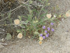
Sand Blazing Star flowers in the Joshua Tree National Forest
I think this is one of the prettiest flower pictures I took - meaning that it was the prettiest clump of flowers I came across.
Leaving Prescott we drove down on the lovely curvy 89 highway, to the 70 (I think) and then the 60 before finally reaching Interstate 10 that took us over the Colorado back home to California. Along the way was a fantastic show of flowers, particularly as we came down from the hills, but there was not place to stop, so they are just in our memory. We did stop along the 60 to say goodby to the Saguaras (which were on the other side of a fence.) The pictures we got there are in the cactus set.
As we went over the hills toward Palm Springs, I suggested to Hanne that we drive up to the Joshua Tree National Forest, to the Cottonwood Spring area. Since we'd just been siting all day, Hanne agreed, even though she was eager to get to the hotel and pool! Stupidly we went in wearing sandals, which meant that walking wasn't very comfortable. ("Sandal" means shoe that gets full of sand!) But the flowers were still spectacular, even though we heard we were a little late.
Soon after I moved here, Hanne visited us in February 2001 and wanted to see the desert. So we had gone to the Northern Entrance near 29 Palms. There were few flowers out then, but we loved climbing on the rocks, and saw some petroglyphs. A month later, John and I had come out to Cottonwood and taken a much longer walk than we did in our sandals. I have all those pictures on Snapfish. I'll have to see about uploading them here.
Particularly seeing the cactus bloom was an incredible experience.
Friday, April 25, 2008
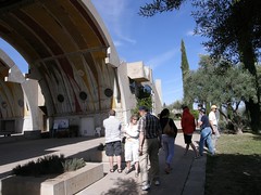
Arcosanti and then Prescott
My Mom kept telling us about this unusual location along our route. We missed it going to Sedona, since our trip was so long, but since we left the Grand Canyon early, we figured we could catch it - and Montezuma's Castle, which we'd just heard about - on a round-about way to Prescott.
My father's sister, Betty, had worked in Talliesin with Frank Lloyd Wright in the early 50's, and there she must have met Paolo Soleri, the Italian artist/artisan/architect who conceived and built this urban experiment in the desert, which he called Arcosanti. Mom and Dad visited Arcosanti when Betty joined them at an Elder Hostel in Arizona. She took them both here and Cosanti, visiting with Soleri and his wife, and to Betty's old stomping grounds Taliesin.
Soleri had grand plans for a city with 5,000 residents, who would work and play in Arcosanti. His design includes wonderful arches and apses is intended to have what we now would call a tiny footprint on the environment. His choice of materials - most concrete - were chosen so that volunteers and interns with little or no construction experience would be able to work together to turn his vision into the actual city. The site was originally funded by some quirky ceramic and bronze windbells that Soleri and his wife made at their first location Cosanti.
Unfortunately, the city never really reached the proportions he envisioned. There are now about 100 people on site at any time, so living there permanently, some interns and some paying volunteers, as well as other guests. There are workshops on the urban environment and construction methods, where the interns and volunteers help construct a little more of the vision, and there are windbell making courses as well, since they are still a major source of income. Hanne, the business woman, could get all the numbers to add up here, and considered it a 70's utopia (she was born in 1970 - so that is the folly's of her parents' generation!)
I did buy a little ceramic windbell, which we haven't hung up yet. I'll add a picture when we do.
After our visit here, we crossed the I 17 and headed for another PEO B&B at Sally and Gregg's in Prescott, which prides itself on being a cowboy town. In fact Prescott was the only area we actually saw working beef ranches with grazing cattle. We were told that sometimes there are also antelope grazing with them, but we missed them.
We had dinner, at the recommendation of our hosts, at the Palace Restaurant and Saloon , where we just happened to hit the monthly Monday night show night, which was a blue singer accompanied by a fiddler and lots of fun!
What impressed me most about Prescott was the black sky, where you could see all the stars and a tiny sliver of moon. They have an ordinance forbidding street lights! (I was looking for a link about the wonderful dark sky, and discovered that not everyone think it's a good idea. To read the grump's opinion, look at Light Sky, Dark Sky.)
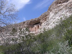
Montezuma's Castle
What a great location!
This Anasazi apartment complex in the cliff was built several centuries before Montezuma, but when it was discovered in the early 19th century, the explorers thought it was built by Montezuma's men escaping the Spaniards. According to the Verde Valley Guide, the people who built this are called "Sinagua" (without water) which seems strange, since they have a nice creek here, and there is quite a large spring-fed pool nearby dubbed "Montezuma's Well."
At any rate, they evidently moved into this area around 1125 AD, pushing out what was left of the Hohokam, who had been there since 600 AD. Originally they'd lived in huts, but they started to figure out masonry (there was probably a good supply of mud near the river.) Archeologists figure they started this cliff dwelling around 1150, and by 1300 had about 150 residents in 20 rooms in 5 stories. But then they disappeared in the early 1400's (note, before Columbus) but apparently took all their stuff with them, so they didn't just die off. An interesting puzzle. The Anasazi are the subject of a long section in Jared Diamond's book Collapse: How Societies Choose to Fail or Succeed
Hanne and I felt often during this trip that we were following in my parents' footsteps. We called Mom every evening and she could easily follow along on our route, because they had been there on several different trips. She also made several suggestions (like Arcosanti) for excursions.
When we were kids living in New Jersey, Dad was mechanical engineer working for Esso. We were waiting for the year he would have saved up 5 weeks of vacation, so we could do our cross-country trip to visit our cousin Sadie in Berkeley and see Yellowstone and the Grand Canyon and whatever else of interest lies between New Jersey and California. But Dad switched jobs, we moved to a new part of the world we could explore (Ohio) and we never had enough vacation after that to go that far. Instead we went on camping trips to the Laurentians in Ontario, and to the top of Michigan's lower peninsula (they were building the bridge at the time.) So I never got west until John asked me to join him in California 8 years ago. My sister Lu was a hippy in San Francisco for a while, and of course Sadie still lives in California. Since Mom was born in Santa Barbara, we also have a lot of relatives out here, but I'm just getting to know more about them now.
But Mom and Dad discovered America's early history when Dad retired and my son suggested we visit a place called America's Stonehenge in Salem, NH. Dad soon started a new career as amateur archeologist working closely with the New England Antiquities Research Association, studying America before Columbus. This got them intrigued with other early American sites. They traveled to Mexico and Central America, studying early Mayan ruins and pyramids, and went to several Elder Hostels in Arizona and New Mexico, where the theme was native archeology. And every time they visited us in Denmark after that point, they were out looking for petroglyphs and stone settings, or studying museums.
Much earlier we also had quite an influx of native American culture, because Dad's sister Betty worked for a while with Frank Lloyd Wright at Taliesin West in Scottsdale, AZ (which Hanne and I didn't have time to visit, unfortunately.) Her home was filled with Navajo artifacts: lovely baskets and bowls, woven shawls and dolls. We received Navajo gifts as well, like Kachinka dolls. Hanne and I saw things like hers in museums, but the native craft shops were selling much less artistic, more factory-like products, so we weren't tempted to buy any of that.
Thursday, April 24, 2008
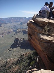
Hanne, my hero at the South Kaibab trail
This picture doesn't show Hanne, but it shows the Ooo-ahh Point, where our hearts stopped momentarily. Guaranteed the scariest part of the hike down into Canyon by the South Kaibab trail. Hanne made a great video from this location, which you can see in the collection of pictures. I'm glad she didn't get me in it, because my face was white
But that isn't why Hanne is my hero. That was much later.
We chose this trail over the other option, the Bright Angel trail, because it goes down faster. That meant we'd get further into the canyon in our allotted time (and with our allotted strength and provisions.) There is a great rest area at Cedar Ridge, where the mule trains stop, and there are composting toilets (with solar panels.)
So we had great time getting down. Although I did notice it in my knees, they held up. I think Hanne would have preferred to go about twice as fast, but she sweetly waited for me along the way. We agreed that I would do some R&R at Cedar Ridge, eating some of the sustenance I'd brought, maybe reading some of the Danish book I'd been working on, or taking pictures, and then start back up. In the meantime, she would hike on down another 20 minutes or so (there's a zoomed-in picture of here skipping down the stairs,) and then meet me whereever I happened to be when she got back, which wasn't very far above the rest stop.
I discovered that, although my knees weren't so bad going back up, it all required a lot more energy and breath. I found myself breathing heavily using chest breathing, and would lecture myself to breathe with stomache muscles like we were taught in Chorale. I'd take 10 steps and stop to breathe, and then maybe a few more. I took very few pictures on the way up! If you compare the number of pictures Hanne took and I took, for a change, she was the big photographer!
I met a (slightly younger) couple - from Kansas City - having as much difficulty as I did, and we watched for Hanne for a while, until suddenly, there she was. Hanne quickly suggested that we switch knapsacks. Even though I'd eaten most of my stash (and she hadn't,) there was still my book and camera - and whatever else I had - weighing down. She chided me on not packing properly! So she would walk up a bit and turn around and wait a bit, and was getting worried that I wouldn't make it. When we got to the very nasty switchback part going up the vertical cliff side, she left me with the other couple, taking both our knapsacks, and happily strolled up the hill to the top, where we found her much later happily reading her book! At least Hanne had read that the hike to Cedar Ridge and back should take 3-5 hours, and did it in 3 1/2 (she of course went further and did it in 3!) So she was impressed anyway that I actually did it - even though she ended up with both knapsacks!
Along the way we met some groups who were hiking all the way down to the river, where there is a ranch. At the bottom, it connects up with the Bright Angel trail, and there is even a bridge over the river for those who want to go up the North Kaibab trail to the north rim.
About the same time I arrived at the top, a young couple with large knapsacks also surfaced, after 2 nights at the ranch. They said it was exhausting but a wonderful experience. And old ranger we met at the Ooh-ahh Point said that it was very rare until recently for peole to hike all the way. Most took mules. I saw mule trains with people, and others packed with provisions in and waste out. And all along I had the mule theme from the Grand Canyon Suite in my head.
After that experience, we took the shuttle bus to the Grand Canyon village, where we got an expensive hamburger and then headed back to the hotel for a soak in the hot tub. (There were too many kids in the pool to be able to swim. Dinner that night was at the "Spaghetti Western" a couple of doors down the road from the hotel.
Tuesday, April 22, 2008
First views of the Grand Canyon
After our exerting day in Sedona, our drive to the Grand Canyon was a rest day.
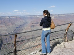
When we got to the canyon (another jaw dropping experience!) we gazed down into the canyon safely from behind bars and walls, along with people from all over the world, many from Asia, but also some speaking languages we know - German, Dutch, Swedish. It was interesting studying the layers - and noticing the red rock several layers down. But the river was hard to get an eye on. One of the pictures in the Grand Canyon - South Rim set is a zoom to an area I thought might be river, and it appears to be so.
Then we went to the visitors' center to plan our short time at the canyon. We knew we wanted to hike down into the canyon the next day, so we had to pick a path. More on that in the next entry. There is a 20 mile road along the South Rim that ends up at Desert View, a fascinating visitors' center was built in the 30, designed by the same architect, Mary Colter, who designed the Bright Angel Hotel, where we later had dinner. She designed a wonderful Watchtower there, which is meant to mimic the Anasazi towers - although the windows are all glassed in, which we appreciated as a way to avoid the cold winds! You can read more about it through the link, and see the pictures I took of the inside in the South Rim set.
We also found out that there was a star-viewing talk at 8 pm, but by that time we were ready to go back to the hotel! (And it was cold!) Leaving the restaurant we saw about our only example of wildlife that wasn't a bird, squirrel or insect - a raccoon couple trying to cross the road. That got across in from of us, but we don't know how they fared on the other side of the road.
Enjoy the pictures from the surface. Tomorrow you get to follow us down the cliff!
Monday, April 21, 2008
Northern Arizona's variety of landscapes
I missed yesterday, but I did have time to fix the Flagstaff and Oak Creek area set of pictures, which show how varied northern Arizona can be.
Hanne was really tired the day after all the hikes and climbing the red rocks, so I got to drive for a change, on the kind of roads I love - curving and hilly in the start, and wide open spaces afterwards.
Leaving Sedona, we took 89A north along Oak Creek, through the large ponderosa pine forest and up to an altitude of about 7000 ft, where there were still many patches of snow around, and it was quite chilly! There was a rest area at the top, after the road did a lot of switch backs to get there. You can see them in some of the pictures. There was also a market for local native American products - baskets, pottery and jewelry, but we weren't tempted.
In Flagstaff we drove north through town (on Rt 66, which also runs through Upland!) We missed a turn, so we ended up in the old town part of Flagstaff, which was fun. Then we turned onto US 180, the back (but more direct) route to the Grand Canyon. In Flagstaff we started getting views of the beautifully snow-capped San Francisco Mountain Range. We must have driven through a pass, which was up to our highest altitude at about 8045 ft, and we drove past a sign to Arizona's Snow Bowl, the skiing area, which I expect still has enough snow.
After that the road became straight as an arrow, first going through the Ponderosa forest with large clearings every once in a while, where there were homes and businesses, including a ranch that evidently had white buffaloe behind a very high fence. We weren't tempted there either (Hanne was sleeping beside me.)
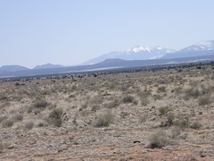
After a while the ponderosas thinned out at we were driving on what we wanted to call "prairie" or maybe "range," but I saw called the "grassy desert," which is a pretty apt name, when you look closer to the picture. There were occasional buildings - trailers and small homes, but no ranch houses, barns or even cattle. There were signs to watch for things like antelope, but we didn't see them either. Just wide open spaces, with the mountains to the south and the Grand Canyon and a slight butte to the north. It was so windy, that sometimes it was hard to keep up to the speedlimit, while once it just took of and pushed me up above 80 mph without my noticing it!
We arrived at the Grand Hotel in the village of Tusayan about noon, and did some mostly driving exploration that afternoon. But that will be in the next entry.
Hanne was really tired the day after all the hikes and climbing the red rocks, so I got to drive for a change, on the kind of roads I love - curving and hilly in the start, and wide open spaces afterwards.
Leaving Sedona, we took 89A north along Oak Creek, through the large ponderosa pine forest and up to an altitude of about 7000 ft, where there were still many patches of snow around, and it was quite chilly! There was a rest area at the top, after the road did a lot of switch backs to get there. You can see them in some of the pictures. There was also a market for local native American products - baskets, pottery and jewelry, but we weren't tempted.
In Flagstaff we drove north through town (on Rt 66, which also runs through Upland!) We missed a turn, so we ended up in the old town part of Flagstaff, which was fun. Then we turned onto US 180, the back (but more direct) route to the Grand Canyon. In Flagstaff we started getting views of the beautifully snow-capped San Francisco Mountain Range. We must have driven through a pass, which was up to our highest altitude at about 8045 ft, and we drove past a sign to Arizona's Snow Bowl, the skiing area, which I expect still has enough snow.
After that the road became straight as an arrow, first going through the Ponderosa forest with large clearings every once in a while, where there were homes and businesses, including a ranch that evidently had white buffaloe behind a very high fence. We weren't tempted there either (Hanne was sleeping beside me.)
After a while the ponderosas thinned out at we were driving on what we wanted to call "prairie" or maybe "range," but I saw called the "grassy desert," which is a pretty apt name, when you look closer to the picture. There were occasional buildings - trailers and small homes, but no ranch houses, barns or even cattle. There were signs to watch for things like antelope, but we didn't see them either. Just wide open spaces, with the mountains to the south and the Grand Canyon and a slight butte to the north. It was so windy, that sometimes it was hard to keep up to the speedlimit, while once it just took of and pushed me up above 80 mph without my noticing it!
We arrived at the Grand Hotel in the village of Tusayan about noon, and did some mostly driving exploration that afternoon. But that will be in the next entry.
Saturday, April 19, 2008
Jaw dropping: Sedona Red Rock Country
Sedona Red Rock Country - Airport Rd Lookout
Originally uploaded by bonbayel
We had to stop at the first lookout we came to - Bell Rock, just at sunset. And then we went on to dinner downtown (hamburgers) and then our first PEO bed & breakfast with Gertrude, who lived very close to the old part of town where we'd found dinner.
Gertrude told Hanne about where she walks everyday, so Hanne got up early the next morning and had a lovely run up and down hills with glorious views of the red rocks. Imagine living there!
Then we went on to the tourist office where we were given maps and suggestions for a couple of hikes that included a bit of climbing.
We started at the Faye Creek trail, which ran along and across the creek for quite a while and Hanne was getting impatient to climb. At the end, we ended at a wonderful place to climb up to get great pictures, which you can see. On the way back, we turned at a little cairn to cross the creek and then go high up the cliff, where the rocks form a wonderful arch. On the way up we were surrounded by the wildflowers we had been looking for.
After lunch we decided to try the Airport Loop trail. By this time I was getting a bit tired, and the blisters on my feet from San Diego were not helping much, so we agreed that Hanne could go on ahead (to get her heart rate up!) First we climbed the lookout hill, from which she took this video. If you look careful toward the end of the video, you'll see that I made it to the top - wearing the green dress, hiking shoes and safari hat I used for all these hikes!
Then Hanne took the airport loop trail (the airport is at the top of a mountain) while I read the long Danish novel she'd brought for me that I had to finish before she left.
Now that I'm home I've discovered I'm not getting any exercise at all. I really miss my hiking companion!
Friday, April 18, 2008
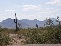
Looking for tall cactus
When I moved to California I was curious about the desert. I figured all desert looked like "The Living Desert" or else where Snoopy's brother lives - you know with those tall sentinel cactusses (cacti?)
But there were only these small fuzzy churro cacti, or some small prickly pears, although there was a field of largish cacti in a field behind my first job here in Rancho Cucamonga (food crop, I have since learned, encountering them on menus in Mexican restaurants.
As we were planning this trip, I read that those tall cacti are Saguara (pronounced [sawara] of course, although it was hard to stop using the [g],) and that they only grow in Arizona. So that became a major item on our "must see" list.
After we crossed the Arizona border we looked and looked. but didn't see any. It was only after we turned north from the 8 towards Phoenix that we began to see a few individuals. I was sure we were going to miss them, so I started taking pictures from the car window of these isolated cacti. But the further north we went the more there were up to a certain altitude - and on the way back we saw many more. They were often in fields with lovely yellow flowers.
So this is something you can only see in Arizona. Pretty neat state!
Thursday, April 17, 2008
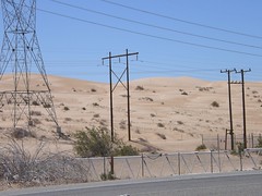
Imperial Dunes
This isn't a pretty picture. Go to the set Interstate 8 CA-AZ to see some pretty ones.
But this is what one end of Interstate 8 looks like in California. The other is mountains out of San Diego, and in between is the very flat farmland area of Imperial County, where much of the fruit and veggies you eat from California come from in the winter. That area has been heavily irrigated from the Colorado River for years. Nowadays there are agreements to send on some of the water to San Diego, so the farmers are working out more efficient methods for transporting and using the water! Some of the water goes on to Mexico, where it is also used for irrigation, so the Colorado rarely reaches the Bay of California any more.
We crossed the Colorado going out at Yuma (there's a picture in the set) and coming back at Blythe on Interstate 10. And of course we saw it several times at the Grand Canyon. (That's not easy - there are so many rocks in the way, you have to be in the right position!)
But of course, being here at the border, maybe I should muse about the people who cross the border against the flow of the Colorado. They must really want to come, if that's the way they try to enter. But I'll save that topic for another time.
Wednesday, April 16, 2008
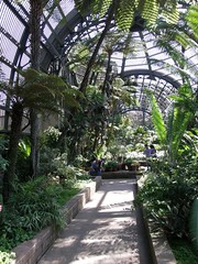
San Diego Balboa Park - Botanical building
In San Diego we loved Balboa Park, and were fascinated by this building, which was constructed mostly of wooden slats. Balboa Park was built for a World's Fair about 100 years ago.
Strangely, we didn't take any pictures in the zoo, which we walked through from one end to the other. I think we couldn't picture happy pictures of animals in cages, while orchids in this building are lovely and inspiring.
It made me think about what zoos and botanical gardens are for - partly to show us curious things from other parts of the world, partly to save those things from extinction. But sometimes plants and animals escape from the confines of gardens or yards and play havoc with native plants and animals, which we then have to put into gardens or zoos to protect. (Humans are some of those animals that have gotten into the wrong habitat and are destroying it - that's why we need the zoos!)
There are other things that we saw protected in San Diego: the old Gaslight Quarter saved from being razed for new modern building, or the Old Town and Little Italy, recalling some of the cultures that came to the where San Diego stands, introducing new plants and animals, cultures, buildings.
I once read that a town with a lot of old buildings is pretty much a museum, and static. A town with a variety of buildings shows its history and is dynamic. Of course some towns look to be completely new. Los Angeles has had a way of remaking itself throughout its career, ignoring the old, although there are those who want to bring the old LA back to life like the Gaslight Quarter. But we didn't see much life there in the Gaslight Quarter, other than convention goers eating at sidewalk restaurants up and down the streets. Does the "real" life maybe need the new, while the old and preserved is for our R&R and entertainment?
Another kind of zoo or botanical garden or museum are our national parks, which Hanne and I enjoyed immensely. Teddy Roosevelt understood that we have to save places and geology as much as plants and animals. This is even more important now than in his time: cities sprawl out into farmland (that destroyed whatever was there before) and there are those who prefer despoiling these areas to get the oil and other minerals from beneath their surfaces.
Can we have our cake (or plants, animals and landscapes) and "eat" it too with our modern culture?
Tuesday, April 15, 2008
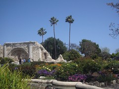
...and the swallows came back to Capistrano
Evidently the swallows had just arrived a couple of days before we came to Mission San Juan Capistrano, which we reached by the lovely Ortego Highway through the Cleveland National Forest.
Hanne had left Denmark in very early spring - with snow for Easter, so she was looking for sun, warmth, and flowers. We found everything here in Capistrano - an excellent start on our vacation! (Or almost everything - most of the time our weather was beautiful, but a little chilly for swimming in pools and sunning on decks.)
It's amazing what California has to offer - just Southern California, in fact. Where we live along the Interstate 10 and 15 corridors are millions of house, warehouse, malls, factories, offices. Our urban (and previous agricultural) origins were the trains. The rail owners wanted people to use the trains, so they encouraged settlements along them. I understand that back when Upland was settled, there was a long wet spell, so it seemed our area was perfect for agriculture, and there was enough water for everyone.
We are hemmed in on all sides by the mountains of the Angeles, Cleveland and San Bernardino National Forests, with their variety of wildlife, including bears and wild cats. In our own patio we have seen an opossum and the lizard I described a few post back - as well as numerous feral cats, humming birds (who for the time being aren't interested in the feeder my husband is so proud of.)
Hanne and I drove the 10 to the 15 down to the town of Lake Elsinore, which has aquired a lot of malls since the last time we were there about 6 years ago. It used to be a sleepy outpost of post-war California, but it's grown up in a hurry. But then we left the Freeway and climbed high above the town, not stopping at viewpoints because we were just starting out. There was a lot of road construction on the "other side of the mountain" down toward Mission Viejo. I guess that explains the malls in Elsinore - people are living (for now) inexpensively there and commuting to jobs in the seaside Orange County towns.
The church ruin at Capistrano was built in the early 19th century by the Spanish monks, but destroyed not long after by an earthquake, killing many of the worshippers in the church. The Spanish mission era didn't last long, either. By 1849, of course, gold was discovered in California, and the distant territory very soon became of interest to the US and annexed as a territory and then a state. (Note: I don't remember dates very well, and I'm too lazy too look them up. Sorry!)
But a chapel remains, the swallows return, and even Americans can't ruin all of the beauty of California.
Monday, April 14, 2008
Mother and Daughter Road Trip
I've been away for a couple of weeks on a wonderful road trip with my daughter, Hanne, who lives in Copenhagen. I figured my next blog entries would tell about some of our experiences. Since I've made 12 sets of pictures from the trip on Flickr, I'll try to write 12 entries with a picture from each location.
You can access all of them from my Mother and Daughter Road Trip Collection on Flickr.
This is not the first trip we have taken alone together. Many years ago, Hanne and I took a trip to Switzerland together while her brother was traveling with their Danish father. Another time, Hanne, who was taking French as a high school freshman, joined me on a trip to Dordogne in France with my own evening school French class.
A couple of years ago, Hanne suggested that we do a trip together to Cancun, which was my first trip to Mexico. Unfortunately, it was only a few months after destructive hurricanes swept through. We managed getting around Cancun by bus, boat and bicycle.
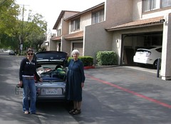
This was our first road trip together. Since Hanne doesn't need a car in Copenhagen, she was delighted to drive most of the trip. We both thought it would be a challenge to use my tiny 2-seater stick-shift 2000 Honda hybrid Insight for the trip. The challenge was both to pack so efficiently that it would all fit (see picture) and to see how good our gas milage would be. We drove about 1500 miles, from sea level at San Diego and in the Imperial Valley to about 8045 ft near Flagstaff, on Interstates, in towns, on windy mountain roads and even dirt roads, so we are very proud of our combined 54 mpg.
You can access all of them from my Mother and Daughter Road Trip Collection on Flickr.
This is not the first trip we have taken alone together. Many years ago, Hanne and I took a trip to Switzerland together while her brother was traveling with their Danish father. Another time, Hanne, who was taking French as a high school freshman, joined me on a trip to Dordogne in France with my own evening school French class.
A couple of years ago, Hanne suggested that we do a trip together to Cancun, which was my first trip to Mexico. Unfortunately, it was only a few months after destructive hurricanes swept through. We managed getting around Cancun by bus, boat and bicycle.
This was our first road trip together. Since Hanne doesn't need a car in Copenhagen, she was delighted to drive most of the trip. We both thought it would be a challenge to use my tiny 2-seater stick-shift 2000 Honda hybrid Insight for the trip. The challenge was both to pack so efficiently that it would all fit (see picture) and to see how good our gas milage would be. We drove about 1500 miles, from sea level at San Diego and in the Imperial Valley to about 8045 ft near Flagstaff, on Interstates, in towns, on windy mountain roads and even dirt roads, so we are very proud of our combined 54 mpg.
Subscribe to:
Posts (Atom)


